On the heels of a great walk in Westerham the weekend before, we decided last weekend to venture a bit farther. We opted for a walking tour of Sevenoaks, a beautiful hilly area about 14 miles outside of London. Led by our tour guide Debbie (with the full tour instructions again downloaded from the internet), we headed off to London Bridge to catch the Southeastern train to Sevenoaks. Working under the false assumption that our Oyster Cards (the card you use everywhere in London for Public Transport fees) would do the trick, we boldly hopped on the train.
Once on the train, we quickly realized that we were “doing it wrong.” London is separated into 6 travel zones and the Oyster Card works in any of those six zones. The area of Sevenoaks, much like the number in its name, is in the area that would be Zone 7, if such a zone existed. We figured this out when the train conductor started down the aisle asking to see everyone’s tickets. Having none, we had to hold our hats in our hands and play the “tourist card.” The Conductor, Didier, from France, was quite helpful except that his debit card machine demagnetized our debit card (that’s another story altogether). Fortunately, Didier was happy to take cash. Whew, we were not going to end up at Scotland Yard.
Once on the train, we quickly realized that we were “doing it wrong.” London is separated into 6 travel zones and the Oyster Card works in any of those six zones. The area of Sevenoaks, much like the number in its name, is in the area that would be Zone 7, if such a zone existed. We figured this out when the train conductor started down the aisle asking to see everyone’s tickets. Having none, we had to hold our hats in our hands and play the “tourist card.” The Conductor, Didier, from France, was quite helpful except that his debit card machine demagnetized our debit card (that’s another story altogether). Fortunately, Didier was happy to take cash. Whew, we were not going to end up at Scotland Yard.
At this point, you may be asking yourself “What does any of this have to do with Cheeseburgers?” We will get to that in due time. Arriving at Sevenoaks Train Station, we headed out for what would become a walk full of beautiful English countryside, livestock, amazing Dutch beer, flowers, a lesson in speaking English, and yes, the Best Cheeseburger in England.
This first part of the walk took us through the residential area of Sevenoaks, down a walled street

and to a small wooden gate that looked like a gate through which one should not pass. But, it was on the map and our tour guide made the executive decision that we should go through the gate. Here’s the gate with a “trespasser” peering out:

What we saw on the other side of the gate can only be explained as breath-taking. The gate opened to Knole Park, where many of the locals go for walks. It was huge, full of Fallow Deer that roamed wild, and led to Knole Estate, where a bunch of royals lived at one point and which was and is used for many films that are set in castles.
The first view of Knole Park that we saw after walking through the gate:
The deer and a close up on one (we were only about 8 feet away from him!):


Walking further through the park, and up some hilly terrain, we came across more deer that looked like they needed a cheering section. They were trying to cross the road/path. Our tour guide cheered them on (and videotaped the crossing, as well as some itching and scratching):
After a royal pee break at the castle (Knole Estate),

we headed onward toward Godden Green. It was another mile or so before we got out of Knole Park (it is quite large); the park is connected to a golf course and we were able to grab a shot of wild deer and golfers sharing the same hillside (you may have to zoom on this photo to see them all – four golfers and a gaggle of deer):

Some more shots of the landscape (wow, this was a beautiful place):


In Godden Green, we stopped at Buck’s Head

a recommended pub/food stop, according to our tour guide. Heads up! The Cheeseburger is almost here! Buck’s Head is a great restaurant and pub situated kind of in the middle of nowhere – it stands alone like a beacon in the countryside, welcoming local visitors and touring walkers whose feet need a rest:

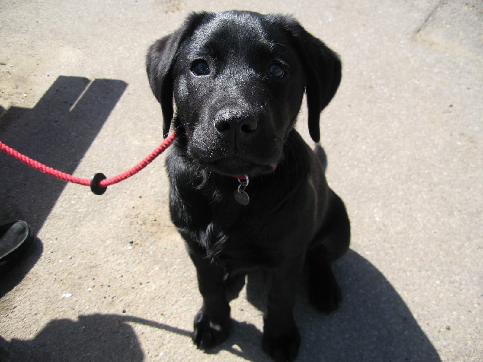
The three best things about Buck’s Head: (1) Toby, the cutest puppy in Kent:
(2) A new and very delicious beer, Oranjeboom (pronounced o-ron-ja-boom), from our tour guide’s motherland, The Netherlands, and (3) wait for it…The Best Cheeseburger in England!!!!! We apologize that there is no picture of the cheeseburgers – we were too busy enjoying them to snap a photo. Technically, we only had to walk 3 miles to get the cheeseburgers, but our entire journey was 6 miles long. We would gladly walk those same three miles again for that burger – wow, really amazing.
Tummies full and opting to swap tour guides to Jon, we started out for what was listed as the second leg of the walk (it was a nine mile walk on the map) – it turned out to be our last leg on the walk. More on that later. Leaving Godden Green, we made our way through several bridleways and walked through farms, apple orchards, and open fields. The sheep farm was set on a rolling hillside and it looked like we were only a few weeks past birthing season (any fans of Gypsy can now start singing Little Lamb):


Side note – as we were traversing several bridleways, we pondered “What’s a bridleway?” We knew the answer right away: “It depends on how heavy her dress is.” <we can hear you groaning> Here is an actual Bridleway:

Side note 2 – we also stopped in to visit Barrack and Michelle:

We ended up at Ightham Mote – an amazing looking house that is surrounded by a moat (but they spell it “mote”), and has a massive garden that looks like the perfect spot for a wedding (assuming the bridle doesn’t way too much).


At this point, our original tour guide, who we will now call Blistery McGee, and our new tour guide, who we will call Mr. Achy Foot, needed a rest. We were 6 miles into our nine mile walk. Stopping for a quick refreshment, we made the official decision that this walk was over. We could go no further. Only God and the British know what there is to see on those last three miles.
This presented us with our final problem of the day – how the hell do we get back to Sevenoaks Train Station to get home? We had no car, there are no trains or buses in the middle of the English Countryside, and (as they like to say in England) “we had lost the will to live.” Thinking smartly, we decided to go to the gift shop at Ightham Mote and inquire about our dilemma. We had seen on a map that there was a bus once an hour at Ightham Common, but we knew not where the Common was.
Big as life, Jon asks “Where is Ightham Common” (pronounced Ig-thumb-common). Stifling a scoff, the clerk said that Ightham (pronounced “item”) Common was about 1.2 miles away and reachable only on foot. No! Not on foot! We only had bloody stumps left below the ankles…Taxi Please!
Ok, well, first, ya can't fool me! I seem to recall that the brit's mile is about a tenth of the 'merkan mile, so you actually only walked a mile and a half. Second, it appears that someone stole the "L" from the sign and it is actually "Lightham Commmon" and not that unpronounceable, at least in English, "Ightham..." Thirdly, isn't a deep fried slab of fish in a bun a called a hamburger in britland? Fourthly, when did brits start playing golf or is that what they call cricket? Glad you're having fun; glad to see most of the snow has melted!
ReplyDeleteLove, Jim
Actually, you planned a 15 mile hike and accomplished 12! Wow! That's pretty good and such beautiful surroundings besides and a good hamburger at the end, how could you ask for any more? Did you finally take a taxi home? Keep up the good work (ignore the lame comments, previous posting)! Jim
ReplyDeleteAnd yes.............we got a taxi back to the train station......
ReplyDelete